Surveying Formula Sheet
Every Formula You Need for GATE CE Surveying — Organised by Topic
Last Updated: April 2026 | GATE CE 2025–2027
📌 How to Use This Sheet
- All surveying formulas required for GATE CE, university exams, and ESE are organised topic-wise below.
- Units: distances in metres, angles in degrees unless noted; d in km for C&R correction.
- For tacheometry: K = 100, C = 0 for modern instruments (internal focusing).
- Curve formulas: Δ in degrees for arc length; in radians only if explicitly noted.
- Bowditch rule applies when linear and angular precisions are equal; Transit rule when angular precision is higher.
- Combined C&R = 0.0673d² (subtract from staff reading); d in km.
- GPS: 4 satellites for 3D fix; DGPS ±1–3 m; RTK ±1–2 cm.
1. Chaining Corrections
True length: Ltrue = Lmeas × (Lactual / Lnominal)
Temperature correction: CT = α (Tm − T0) × L [α = 11.2 × 10⁻⁶ /°C for steel]
Slope correction: Cslope = −h²/(2L) [subtract; h = height difference, L = slope length]
Sag correction: Csag = −w²L³/(24P²) [w = wt/unit length, P = pull in N]
Pull correction: CP = (P − P0) L / (AE) [A = cross-section area, E = elastic modulus]
Combined: Correct length = Measured length + CT + CP − Cslope − Csag
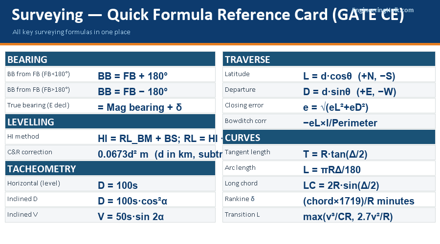
2. Bearings
WCB → QB: 0°–90° → N(WCB)°E | 90°–180° → S(180−WCB)°E | 180°–270° → S(WCB−180)°W | 270°–360° → N(360−WCB)°W
Back bearing: BB = FB + 180° (if FB < 180°) | BB = FB − 180° (if FB > 180°)
True bearing: = Magnetic bearing + Declination(E) | = Magnetic bearing − Declination(W)
3. Levelling
HI method: HI = RLBM + BS | RL = HI − staff reading
Check (HI): ΣBS − ΣFS = Last RL − First RL
Check (R&F): ΣBS − ΣFS = ΣRise − ΣFall = Last RL − First RL
Curvature: C = 0.0785 d² m (d in km, subtract)
Refraction: r = 0.0112 d² m (add)
Combined C&R: = 0.0673 d² m (subtract from observed staff reading)
Reciprocal levelling: True diff = (h₁ + h₂)/2 | Collimation error = (h₁ − h₂)/2
4. Tacheometry
Horizontal sight: D = Ks + C (K=100, C≈0 modern) → D = 100s
Inclined sight: D = Ks cos²α | V = (Ks/2) sin 2α
RL (elevation angle +α): RLB = RLaxis + V − h
RL (depression angle −α): RLB = RLaxis − V − h
RL of axis: = RL of ground station + instrument height (hi)
Stadia intercept: s = top hair − bottom hair reading
Tangential method (both elevation): D = S cos α₁ cos α₂ / sin(α₁ − α₂)
Tangential (one elev, one dep): D = S cos α₁ cos α₂ / sin(α₁ + α₂)
5. Traverse
Latitude: L = d cos θ (+ North, − South)
Departure: D = d sin θ (+ East, − West)
Closing error: e = √(eL² + eD²) where eL = ΣL, eD = ΣD
Accuracy: 1 in (Perimeter / e)
Angular misclosure: Obs. sum − (n−2)×180° (n = number of sides)
Bowditch corr. to L of side i: = −eL × li / P (P = perimeter)
Transit corr. to L of side i: = −eL × |Li| / Σ|L|
Coordinates: En+1 = En + Di | Nn+1 = Nn + Li
Area (coordinate method): A = ½|Σ(EnNn+1 − En+1Nn)|
6. Simple Circular Curves
Tangent length: T = R tan(Δ/2)
Arc length: L = πRΔ/180 (Δ in degrees)
Long chord: LC = 2R sin(Δ/2)
External distance: E = R(sec(Δ/2) − 1)
Mid-ordinate: M = R(1 − cos(Δ/2))
Offset from long chord at dist x from midpoint: Ox = √(R²−x²) − √(R²−(LC/2)²)
Offset from tangent at dist x: Ox = R − √(R²−x²) ≈ x²/(2R)
Rankine deflection angle per chord: δ = (chord × 1719)/R (minutes)
Degree of curve (chord definition): D = 1718.87/R (minutes, R in m)
7. Transition Curves
Length (centrifugal acceleration): L = v³/(CR) [C = 0.3 m/s³, v in m/s]
Length (IRC empirical): L = 2.7v²/R [v in km/h, R in m]
Shift: s = L²/(24R)
Total tangent length: Ttotal = (R + s) tan(Δ/2) + L/2
Spiral angle: φ = L/(2R) radians = L × 180/(2πR) degrees
Length (superelevation runoff): L = e × N × v [N = speed factor, e = superelevation]
Design length = Maximum of all three values.
8. Vertical Curves
Rate of change of grade: r = (g₂ − g₁)/L [g in %, L in m]
Elevation at point x: y = y₀ + g₁x + rx²/2
Highest/lowest point (x from start): x = −g₁/r = g₁L/(g₁−g₂)
Summit curve (L > SSD): L = N×SSD²/(√(2h₁)+√(2h₂))² [h₁=1.2m, h₂=0.15m]
Sag curve (L > SSD): L = N×SSD²/(2H+2SSD×tanα) [H=0.75m, α=1°]
N = |g₁−g₂|/100 (algebraic difference of grades)
9. GPS & EDM
GPS 3D fix: Minimum 4 satellites required
GPS accuracy: Standard ±15 m | DGPS ±1–3 m | RTK ±1–2 cm
NavIC: 7 satellites, covers India + 1500 km, accuracy <20 m
EDM total error: ε = ±√(a² + (b×D)²) [a = constant error in mm, b = scale error in ppm, D in km]
Atmospheric correction to EDM: Catm = (Nstd − Nactual) × D × 10⁻⁶
Radiometric resolution: Grey levels = 2^(bit depth)
Spatial resolution: Ground pixel size = (altitude × sensor IFOV)
Frequently Asked Questions
What is the formula for curvature and refraction correction?
Combined C&R = 0.0673d² metres (d in km). Subtract from observed staff reading. Curvature alone = 0.0785d². Refraction alone = 0.0112d².
What is the tacheometry formula for inclined sights?
D = Ks·cos²α; V = (Ks/2)·sin2α. RL of station = RL of axis + V − h (elevation) or − V − h (depression).
What are the formulas for simple circular curve elements?
T = R·tan(Δ/2); L = πRΔ/180; LC = 2R·sin(Δ/2); E = R(sec(Δ/2)−1); M = R(1−cos(Δ/2)).
What is the Bowditch correction formula?
Correction to L of side i = −eL × (length of side i) / Perimeter. Correction to D = −eD × (length of side i) / Perimeter.