Levelling & Contouring in Surveying
HI Method, Rise & Fall, Curvature & Refraction, Reciprocal Levelling & Contouring
Last Updated: April 2026 | GATE CE 2025–2027
📌 Key Takeaways
- Levelling determines the relative heights (RLs) of points on the Earth’s surface referred to a datum.
- HI method: RL = HI − staff reading; faster but checks only the last RL. Rise & Fall: checks every RL; preferred for precision.
- Arithmetic check (HI method): ΣBS − ΣFS = Last RL − First RL.
- Arithmetic check (R&F): ΣBS − ΣFS = ΣRise − ΣFall = Last RL − First RL.
- Combined C&R correction = 0.0673d² m (d in km) — subtracted from observed readings.
- Reciprocal levelling eliminates collimation error, curvature, and refraction in one step.
- Contours crossing a ridge are V-shaped pointing downhill; crossing a valley they point uphill.
1. Definitions & Terminology
| Term | Definition |
|---|---|
| Datum | Reference surface from which elevations are measured. Mean Sea Level (MSL) at Mumbai is the national datum for India. |
| Reduced Level (RL) | Height of a point above or below the datum. |
| Bench Mark (BM) | Fixed reference point with known RL. GTS BM (Great Trigonometrical Survey) are permanent, precisely determined; TBM (Temporary BM) are set for a particular job. |
| Back Sight (BS) | First reading after setting up the instrument; always on a point of known RL (BM or change point). |
| Fore Sight (FS) | Last reading before shifting instrument; always on a change point or final point. |
| Intermediate Sight (IS) | Any reading between BS and FS in one instrument position; on points whose RL is needed. |
| Change Point (CP) | A point where both FS (from old position) and BS (from new position) are taken; staff is not moved between the two readings. |
| Height of Instrument (HI) | RL of instrument’s line of sight = RL of BM + BS reading. |
2. Levelling Instruments
The dumpy level is the most common — telescope is permanently fixed to the spindle, and levelling is done with foot screws. The tilting level has a tilting screw to make the line of sight truly horizontal for each reading — used for precise levelling. The auto level (self-levelling level) uses a compensator (pendulum or prism system) to automatically keep the line of sight horizontal within a small range (±15′); the fastest to use in the field.
The levelling staff is a graduated rod (4 m folding or telescoping, graduated in metres and centimetres, smallest division 5 mm). Staff readings are always taken at the cross-hair (horizontal hair). The bottom of the staff is zero.
3. Height of Instrument (HI) Method
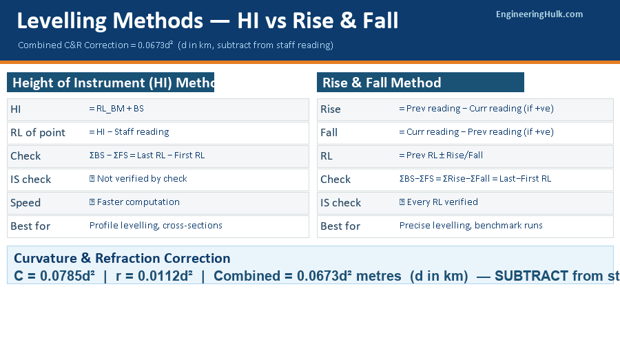
HI Method Formulas
HI = RL of known point + BS
RL of any point = HI − Staff reading (IS or FS)
Arithmetic Check: ΣBS − ΣFS = Last RL − First RL
Note: IS readings do not appear in the arithmetic check of the HI method — this is its key limitation.
The HI method is fast and convenient when many IS readings are taken from one instrument position. However, if a blunder occurs in an IS reading, it is not detected by the arithmetic check. For this reason, it is used in profile levelling, road surveys, and cross-sections where speed matters more than individual check on every IS.
4. Rise & Fall Method
Rise & Fall Formulas
Rise/Fall = Previous staff reading − Current staff reading (+ = Rise, − = Fall)
RL = Previous RL + Rise (or − Fall)
Arithmetic Check: ΣBS − ΣFS = ΣRise − ΣFall = Last RL − First RL
All three must be equal — this checks every RL including IS readings.
The Rise & Fall method is preferred for precise levelling because errors in any IS reading immediately show up in subsequent RLs and the arithmetic check catches any discrepancy. It is slightly slower to compute but provides a complete check on all readings.
5. Types of Levelling
- Simple levelling: One instrument setup between two points — both visible from one position.
- Differential (fly) levelling: Series of instrument setups to carry levels over long distances. Used to establish BMs along a route.
- Profile levelling: Levels taken at regular intervals along a route (road, pipeline, canal) to draw a longitudinal section.
- Cross-section levelling: Levels taken perpendicular to the route at regular chainage intervals.
- Reciprocal levelling: Used across wide obstacles — instrument set up on both banks and readings taken; the mean gives the true difference in elevation.
- Precise levelling: Using precise/digital levels, invar staff, short sight distances (max 30 m), equal BS and FS lengths to eliminate collimation error and curvature effects.
- Trigonometric levelling: Elevation determined from measured horizontal/vertical angles and distance — used in mountainous terrain.
6. Curvature & Refraction Correction
C&R Correction Formulas
Curvature correction: C = 0.0785 d² metres (subtract from staff reading)
Refraction correction: r = 0.0112 d² metres (add to staff reading)
Combined correction = C − r = 0.0673 d² metres (subtract)
Where d = distance in kilometres.
Corrected staff reading = Observed reading − 0.0673 d²
RL of B (corrected) = HI − (Observed FS − 0.0673 d²) = HI − Observed FS + 0.0673 d²
The curvature correction arises because the datum surface follows the Earth’s curvature but the line of sight is straight. The refraction correction is a partial compensation — atmospheric refraction bends the line of sight slightly downward, making objects appear higher than they are. Net effect: objects appear higher by 0.0673d², so the observed staff reading is too large and must be reduced.
For distances under 100 m, the C&R correction is negligible (0.00067 m for 100 m). For 1 km, it is 0.0673 m — significant for precise levelling.
7. Reciprocal Levelling
When levelling across a wide obstacle (river, gorge), equal BS and FS lengths cannot be maintained. Set the instrument near A, read staff at A (close) and at B (far). Then move the instrument near B, read staff at B (close) and at A (far).
True Difference in Elevation
h₁ = staff at A (near) − staff at B (far) [instrument at A side]
h₂ = staff at A (far) − staff at B (near) [instrument at B side]
True difference = (h₁ + h₂) / 2
Error of collimation = (h₁ − h₂) / 2
Reciprocal levelling eliminates all systematic errors simultaneously: collimation error, curvature, and refraction — because these errors affect h₁ and h₂ equally but in opposite directions, and averaging cancels them. Random errors (personal, atmospheric variation) are not fully eliminated.
8. Contouring — Methods & Characteristics
A contour is an imaginary line connecting all points of equal elevation on the ground surface. The vertical distance between consecutive contours is the contour interval (CI); the horizontal distance is the horizontal equivalent (HE). HE depends on ground slope — steep slope → small HE, gentle slope → large HE.
Methods of Contouring
- Direct method: The instrument is set up and points are physically located on each contour line (staff held until reading = contour RL). Slow but very accurate; used for small areas and large-scale maps.
- Indirect method (grid): RLs of a regular grid of points are measured, then contours are interpolated between grid points. Fast; used for large areas. Interpolation assumes uniform slope between grid points.
- Indirect method (cross-sections): Used for roads and railways; cross-sections taken at regular chainage and contours plotted from the section data.
Characteristics of Contours
- All points on a contour have the same elevation.
- Contours never cross except at a vertical cliff or overhang.
- Closely spaced contours = steep slope; widely spaced = gentle slope; equally spaced = uniform slope.
- A contour crossing a ridge is V-shaped with the V pointing downhill (away from the high ground).
- A contour crossing a valley is V-shaped with the V pointing uphill (toward the high ground).
- Contours must close — either within the map or beyond its edges.
- A closed contour with higher values inside = hill; lower values inside = depression (pond, pit) — depression contours are shown with tick marks pointing inward.
- Contours cannot merge (except at a cliff) or split.
9. Worked Examples (GATE CE Level)
Example 1 — HI Method Booking
The following staff readings were taken with a dumpy level. BM = 100.000 m. BS: 1.525, IS: 2.345, 1.980, FS: 0.765 (CP), BS: 1.275, IS: 0.890, FS: 2.105. Find the RL of all points.
| BS | IS | FS | HI | RL | Remarks |
|---|---|---|---|---|---|
| 1.525 | 101.525 | 100.000 | BM | ||
| 2.345 | 99.180 | P | |||
| 1.980 | 99.545 | Q | |||
| 0.765 | 100.760 | CP | |||
| 1.275 | 102.035 | 100.760 | CP | ||
| 0.890 | 101.145 | R | |||
| 2.105 | 99.930 | S |
Check: ΣBS = 1.525 + 1.275 = 2.800; ΣFS = 0.765 + 2.105 = 2.870; ΣBS − ΣFS = −0.070; Last RL − First RL = 99.930 − 100.000 = −0.070. ✓ Check satisfied.
Example 2 — Curvature & Refraction (GATE 2021 type)
An instrument is set up at A. A staff is held at B, 2 km away. The observed staff reading is 2.855 m. RL of A = 150.000 m, HI above A = 1.400 m. Find the RL of B correcting for C&R.
Solution:
Combined C&R = 0.0673 × 2² = 0.0673 × 4 = 0.2692 m
Corrected staff reading = 2.855 − 0.2692 = 2.5858 m
HI = 150.000 + 1.400 = 151.400 m
RL of B = HI − corrected staff reading = 151.400 − 2.5858 = 148.814 m
Example 3 — Reciprocal Levelling
Instrument at A side: staff at A = 1.285 m, staff at B = 2.860 m. Instrument at B side: staff at A = 0.980 m, staff at B = 1.050 m. Find the true difference in elevation and the collimation error.
Solution:
h₁ = 1.285 − 2.860 = −1.575 m (B is 1.575 m below A)
h₂ = 0.980 − 1.050 = −0.070 m (Hmm — this seems inconsistent; let me recalculate)
Using the correct form: h₁ (A higher) = staff_A_near − staff_B_far = 1.285 − 2.860 = −1.575 m
h₂ = staff_A_far − staff_B_near = 0.980 − 1.050 = −0.070 m
True difference = (−1.575 + (−0.070))/2 — Wait: the formula should use absolute magnitudes.
Correct interpretation: from A side, B appears 1.575 m below A. From B side, A appears 0.070 m above B (i.e., A is 0.070 m higher than B). True diff = (1.575 + 0.070)/2 = 0.823 m (A is higher). Error of collimation = (1.575 − 0.070)/2 = 0.753 m (large error in far reading).
Common Mistakes
- Using C&R correction with wrong sign: Objects appear higher when viewed over long distances (refraction brings them up). The staff reading is too large. Always subtract 0.0673d² from the observed reading.
- Forgetting the arithmetic check for IS readings in HI method: The check ΣBS − ΣFS = Last RL − First RL does not verify IS readings. A blunder in IS goes undetected unless you use the R&F method.
- Reading the staff upside down: Always read from bottom to top. The lowest visible graduation is read first, then the next. Never read through a horizontal line of the E-staff accidentally.
- Confusing contour V-direction: Memorise — V pointing downhill = ridge; V pointing uphill = valley. Think of water flowing down the V of a valley.
- Misidentifying BS, IS, FS: BS is always first after setup (on known point). FS is always last before shifting. Everything in between is IS. A change point gets both a FS (from old setup) and a BS (from new setup).
Frequently Asked Questions
What is the difference between HI method and Rise & Fall method in levelling?
In the HI method, RL = HI − Staff reading. It is faster but the arithmetic check does not verify IS readings. In the Rise & Fall method, differences between consecutive readings give rises or falls, and the check ΣBS − ΣFS = ΣRise − ΣFall = Last RL − First RL verifies every RL including IS readings. Both give identical final RLs when computed correctly.
What is the combined curvature and refraction correction?
Combined C&R correction = 0.0673d² metres, where d is in kilometres. Curvature (0.0785d²) makes objects appear lower; refraction (0.0112d²) partially compensates by bending the line of sight downward. The net effect is that staff readings appear larger than true; hence the correction is subtracted.
What is reciprocal levelling and why is it used?
Reciprocal levelling is used across wide obstacles (rivers, valleys) where equal BS and FS lengths are impossible. The instrument is set up near both banks in turn. Averaging the two observed differences in elevation eliminates collimation error, curvature, and refraction simultaneously.
What are the characteristics of contours?
Key characteristics: contours never cross (except vertical cliff); closely spaced = steep slope; V pointing downhill = ridge; V pointing uphill = valley; closed contour with higher values inside = hill; depression contours have tick marks. All points on one contour have the same elevation.